Map
General information
The map shows you a graphical representation of the world, and is the key tool for navigating through the game.
There are two maps shown on the map screen. The first, located on the left of the screen, shows a close-up of your immediate surroundings. You can either use the arrow keys surrounding the map to move around, or click and drag (if you have a modern browser).
Hovering your mouse over a village will show you basic information about the village. If you've turned on the context menu, clicking on a village will give you a number of possible actions related to that village, such as the sending of troops or resources.
The smaller map on the right represents a much larger section of the world.
Continents
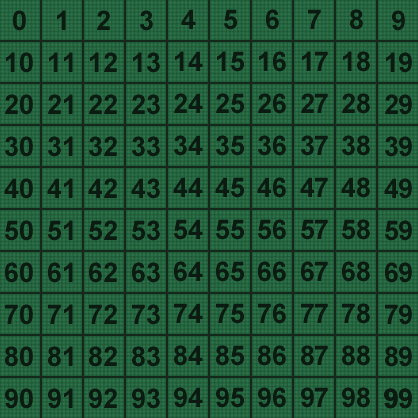
The map is split into 100 continents, each 100x100 squares in size. The image below shows how the continents are laid out. When you're in-game continents are normally represented in the format Kxx, where the xx is the number of continent e.g. K55.
Displayed information

On worlds with the Church enabled, you can click on Display influence area of religion to show circles on the map showing your Churches' radius.
If you have a Premium account you can enable the political map by clicking on Show political map. This colourizes the top right map as can be seen in the example image.
The Activate context menu option toggles the availability of the context menu, as described above.
Premium account owners can opt to resize the map to any of the following sizes:
- 4x4
- 5x5
- 7x7
- 9x9
- 11x11
- 13x13
- 15x15
- 20x20
- 30x30
- Custom size (drag the side of the map)